
Quick answer
Venice sits in a lagoon at the top of the Adriatic Sea, in northeast Italy, joined to the mainland by one rail and road bridge. The historic center is six districts, the sestieri, set around the S-shaped Grand Canal: trains and buses arrive at the west end, and St. Mark’s Square is at the southeast, about 30 minutes on foot or 41 minutes on vaporetto line 1. Murano and Burano lie to the north, the Giudecca to the south and the Lido to the southeast.
Prices and times checked on 14 November 2026.
How Venice is laid out
The map tiles come from OpenStreetMap: loading them sends your visit data to their servers.
- Sights
- Vaporetto stops
- Arrival points
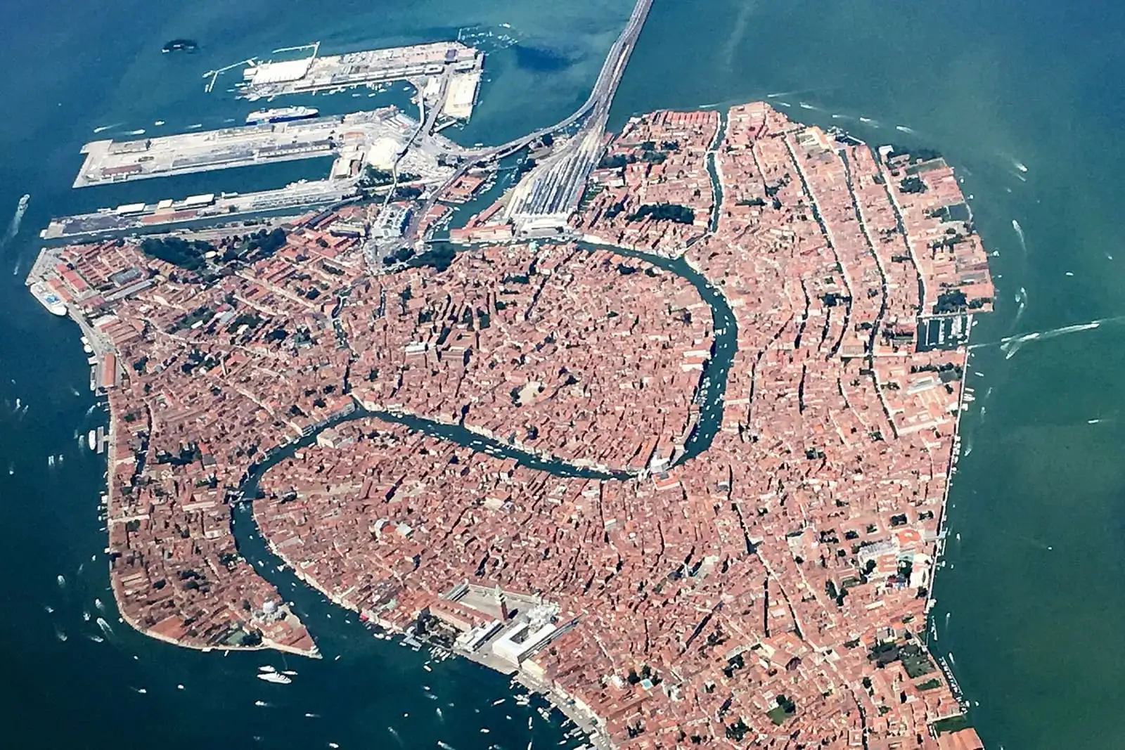
Seen from above, the historic center has the outline of a fish. The Grand Canal runs through it in a reverse S for 3.8 km and splits it into two unequal parts. Cannaregio, San Marco and Castello lie on one side; Santa Croce, San Polo and Dorsoduro on the other. Only four bridges cross the Grand Canal: the Costituzione and the Scalzi by the station, the Rialto in the middle and the Accademia near the end.
Four points will keep you oriented:
- Santa Lucia station and Piazzale Roma, the west end. Trains stop at the station, in Cannaregio, and buses, taxis and cars stop at Piazzale Roma, in Santa Croce, across the Costituzione bridge. Both stand at the lagoon end of the rail and road bridge from the mainland.
- The Rialto Bridge, the middle of the city and of the Grand Canal. From the station it is 22 minutes on foot, 1.6 km.
- St. Mark’s Square, the southeast corner, on the water. It is 7 minutes on foot from the Rialto.
- The Accademia bridge, the southern crossing to Dorsoduro, 13 minutes on foot from St. Mark’s Square.
Everything beyond the historic center is reached by boat: the Giudecca across a wide canal to the south, the Lido on the sea, and Murano, Burano and Torcello in the lagoon to the north.
Where is Venice in Italy?
Venice is in the northeast of Italy, at the top of the Adriatic Sea, and is the capital of the Veneto region. It stands in the middle of a lagoon of 552 square kilometers (213 square miles), about 52 km (32 miles) long, cut off from the open sea by a chain of long, thin islands, the Lido among them. On a world map, it sits at about the same latitude as Portland, Oregon, and Montreal.
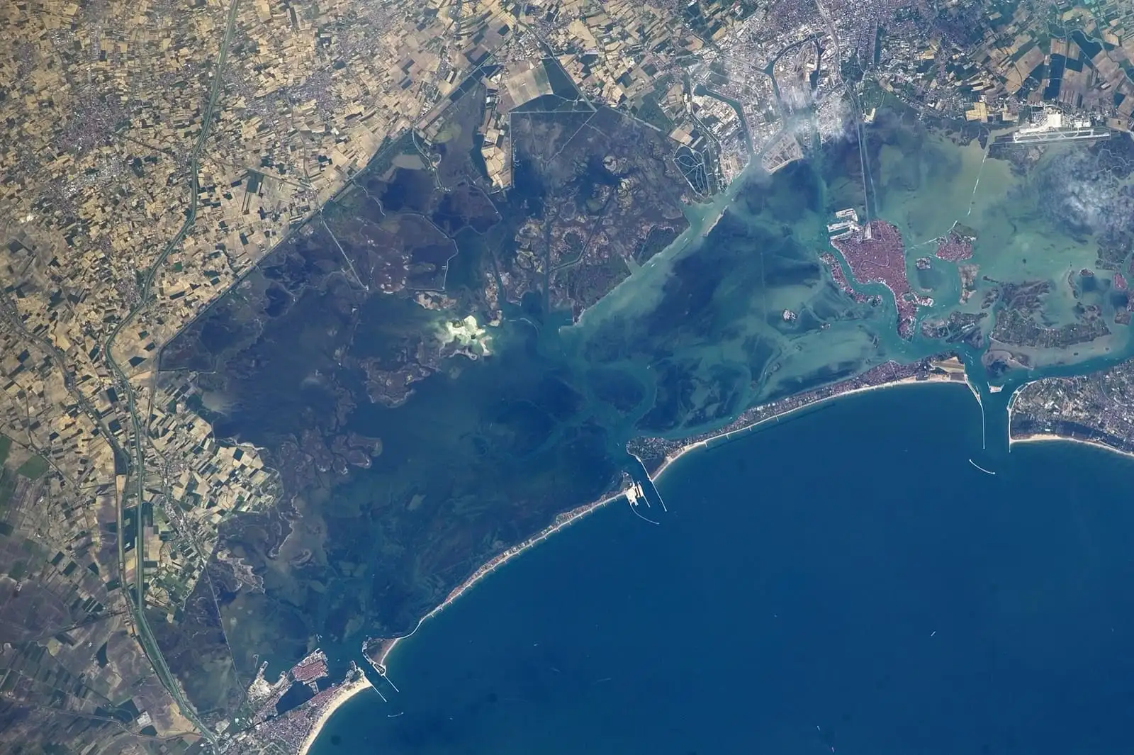

The Venetian lagoon seen from the International Space Station, with Venice on the right and the barrier islands along the sea.
The city was built on 118 small islands. The first train crossed the lagoon in 1846, cars followed in 1933, and trains and cars still reach the city only across that bridge. Marco Polo Airport is on the mainland, about 20 minutes from Piazzale Roma on ACTV bus line 5, and our airport guide compares the bus, the boat and the water taxi.
| From Venice Santa Lucia | Fastest direct train | Guide | Book |
|---|---|---|---|
| Venezia Mestre, on the mainland | 10 to 14 min, regional train | Staying in Mestre | Check times |
| Firenze Santa Maria Novella | 2 h 13 min, Frecciarossa | Florence to Venice by train | Check times |
| Milano Centrale | 2 h 27 to 2 h 30 min, Frecciarossa | Milan to Venice by train | Check times |
| Roma Termini | 3 h 56 min to 4 h 7 min, Frecciarossa | Rome to Venice by train | Check times |
The six sestieri and what is in each
The sestieri are the six districts of the historic center, and every address carries the name of one of them. You do not need to learn their borders, but knowing which side of the Grand Canal each one is on saves a lot of walking.
| Sestiere | Where it is | What you go there for | Vaporetto stops | Hotels |
|---|---|---|---|---|
| San Marco | Around St. Mark’s Square, in the southeast | St. Mark’s Square, the Doge’s Palace, La Fenice | S. Marco Vallaresso, S. Maria del Giglio, S. Angelo | See hotels |
| Castello | The east end, to Sant’Elena | The Arsenale, the Biennale gardens | S. Zaccaria, Arsenale, Giardini | See hotels |
| Cannaregio | The north, from the station to the Rialto | The Jewish Ghetto, the northern canals | Ferrovia, S. Marcuola, Ca’ d’Oro, F.te Nove | See hotels |
| San Polo | Across the Rialto Bridge from San Marco | The Rialto market, the Frari | Rialto Mercato, S. Silvestro, S. Tomà | See hotels |
| Santa Croce | The northwest, around Piazzale Roma | Arrivals by bus and car, quiet lanes to San Stae | P.le Roma, Riva de Biasio, S. Stae | See hotels |
| Dorsoduro | The south, from the Salute to the Zattere | The Accademia, the Guggenheim, the Salute | Accademia, Salute, Zattere, Ca’ Rezzonico | See hotels |
San Marco is where most visitors spend most of their time. Piazza San MarcoMap opens onto the water, with St. Mark's BasilicaMap and the Doge's PalaceMap on it, and the lanes west of the square lead to Teatro La FeniceMap and the Accademia bridge.
Castello covers the whole east end. Its western edge along the Riva degli Schiavoni feels like part of San Marco; past the Arsenale di VeneziaMap it turns residential, with the Giardini della BiennaleMap and Sant’Elena at the tip. Castello also hides Libreria Acqua Alta, the bookshop with a gondola full of books, 8 minutes on foot from St. Mark’s.
Cannaregio runs from the train station to the Rialto along the Strada Nova. To the north are the long, straight canals, the Jewish Museum of Venice (MEV)Map in the Jewish Ghetto, the church of Madonna dell'OrtoMap and the Fondamente Nove, where the boats leave for Murano and Burano.
San Polo starts at the foot of the Rialto BridgeMap with the Rialto MarketMap. Inland are the Basilica dei FrariMap, home of Titian’s Assumption, and the Scuola Grande di San RoccoMap, covered in paintings by Tintoretto.
Santa Croce is where you arrive by road. The streets by Piazzale Roma are mostly practical, but a few minutes east, toward San Stae, the sestiere turns quiet and residential.
Dorsoduro is the art district. The Gallerie dell'AccademiaMap stands at the foot of the Ponte dell'AccademiaMap, the Peggy Guggenheim CollectionMap is a short walk east, and the domes of Basilica di Santa Maria della SaluteMap close the Grand Canal. The student bars of Campo Santa MargheritaMap and the long, sunny Zattere waterfront are here too.
For which areas suit which kind of stay, see where to stay in Venice.
The main sights on the map, with the nearest stop
Stops and lines follow the ACTV timetable for November 2026. Line 1 calls at almost every stop on the Grand Canal; line 2 makes fewer stops and is faster. Our vaporetto guide covers tickets, passes and the 24-hour pass at €25.
| Sight | Sestiere | Nearest stop (lines) | Tickets and tours |
|---|---|---|---|
| St. Mark’s Basilica | San Marco | S. Marco Vallaresso (1), S. Zaccaria (1, 2) | See tickets |
| Doge’s Palace | San Marco | S. Zaccaria (1, 2) | See tickets |
| Rialto Bridge and market | San Marco and San Polo | Rialto (1, 2), Rialto Mercato (1) | See tours |
| Gallerie dell’Accademia | Dorsoduro | Accademia (1, 2) | See tickets |
| Peggy Guggenheim Collection | Dorsoduro | Salute (1), Accademia (1, 2) | See tickets |
| Frari Basilica | San Polo | S. Tomà (1, 2) | See tickets |
| Jewish Ghetto | Cannaregio | Guglie (4.1, 4.2, 5.1, 5.2), S. Marcuola (1, 2) | See tours |
| Biennale gardens | Castello | Giardini (1), Giardini Biennale (4.1, 4.2, 5.1, 5.2, 6) | See tickets |
| Murano and Burano | Lagoon islands | Murano Colonna (3, 4.1, 4.2), Burano (9, 12, 14) | See tours |
For what each sight is worth and how long to give it, see things to do in Venice, and for the palaces along the water, the Grand Canal guide.
How long does it take to walk across Venice?
About an hour from end to end. On Google Maps, Piazzale Roma to the church of Sant’Elena, at the eastern tip, is 4.6 to 4.8 km and 1 hour 3 to 7 minutes on foot. Most of what you will see sits in a much smaller area:
| On foot | Distance | Time on Google Maps |
|---|---|---|
| Santa Lucia station to the Rialto Bridge | 1.6 km | 22 min |
| Santa Lucia station to St. Mark’s Square | 2.1 to 2.3 km | 30 to 32 min |
| Rialto Bridge to St. Mark’s Square | 500 m | 7 min |
| St. Mark’s Square to the Accademia bridge | 950 m | 13 min |
Those times assume you never stop and never take a wrong turn, so allow more, and remember that most bridges have steps on both sides, which matters with a suitcase or a stroller. The walking tours guide has routes with times.
How to find an address in Venice
In the historic center an address is the name of the sestiere plus a house number, with no street. The Doge’s Palace is San Marco 1, La Fenice is San Marco 1965, and the Salute is Dorsoduro 1. The numbers run through the whole sestiere, so the number tells you the district and almost nothing about the street.
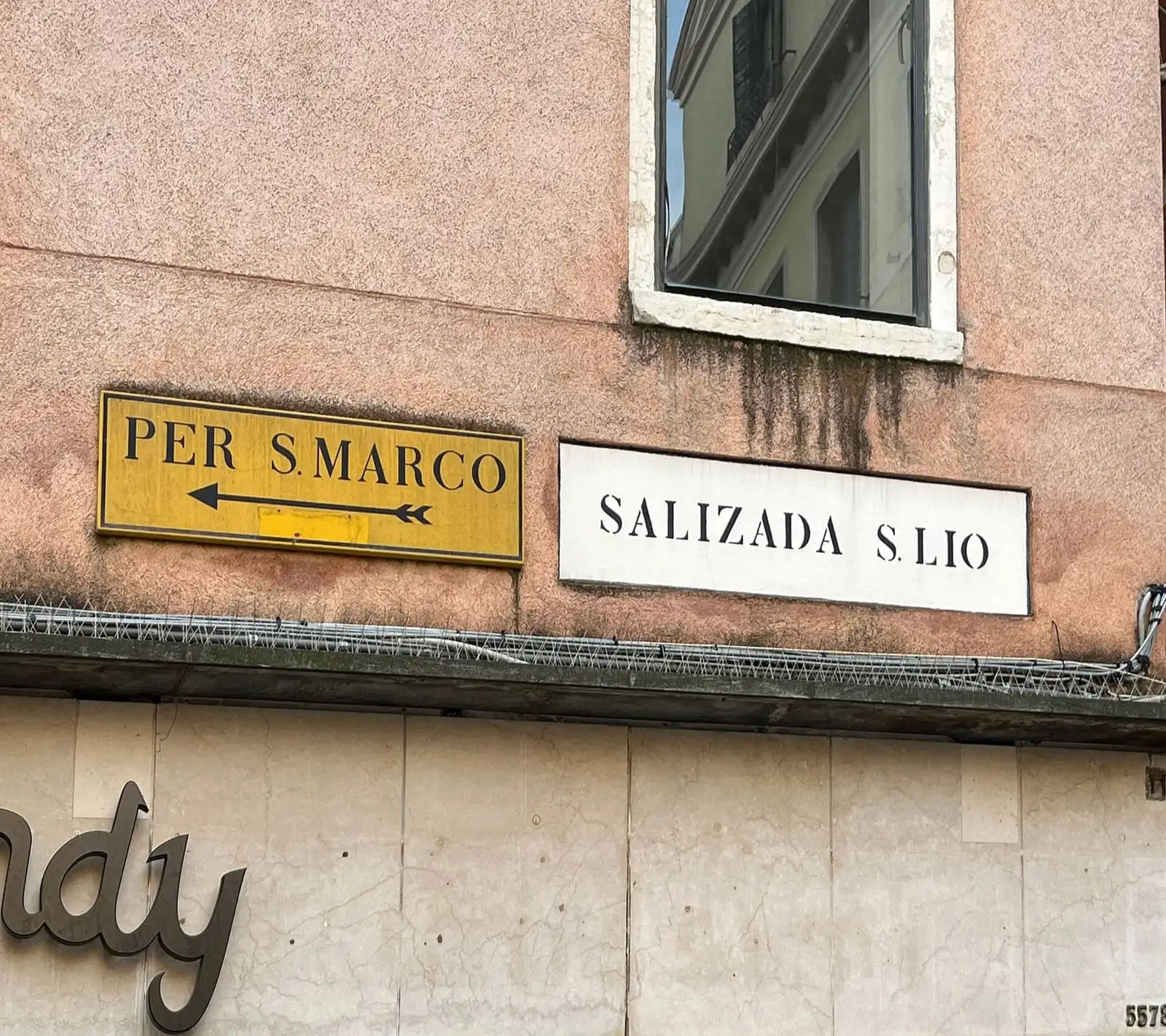

A painted street sign for Salizada San Lio in Castello, next to a yellow sign pointing to San Marco.
Street names are painted on the walls in black on white rectangles that Venetians call nizioleti, and the city’s place-names office restores them every year. Next to them you often find yellow signs that point toward the main landmarks, like the one for San Marco above. The words on the nizioleti tell you what kind of place you are in:
- Calle: a street, usually narrow.
- Campo and campiello: a square and a small square, where several calli meet.
- Fondamenta: a walkway along a canal, at the foot of the buildings.
- Rio: one of the smaller canals that branch off the Grand Canal.
- Sotoportego: a covered passage that runs under a building.
When you book a hotel or a restaurant, ask for three things: the sestiere and number, the street name, and the nearest vaporetto stop. With those, you can find any door.
Does Google Maps work in Venice?
Yes, and it is the map most visitors use. It gives walking routes through the calli, and in transit mode it shows the vaporetto lines and even the pontoon to board, for example line 2 from pontoon B at Ferrovia to St. Mark’s in 19 minutes. Each place in this guide has a map link next to its name.
Two catches are worth knowing before you land:
- Search by name, not by number. A search for the bare address San Marco 1965 drops the pin on Fondamenta Narisi, a different walkway with the same number, instead of on La Fenice. Search the name of the hotel or place, or the street name plus the number, and check the number on the door.
- No walking directions offline. Google Maps lets you download an area, but walking and transit directions do not work offline. In Venice, where you walk everywhere, that means you need mobile data. An Italy eSIM is the simplest fix if your US plan charges for roaming.
The official vaporetto map
The public boats are run by ACTV, and its Consult a map page has the official interactive map of the waterborne routes. The same page has maps of 11 major stops, most of them split into several lettered pontoons: Piazzale Roma, Ferrovia, Rialto, S. Marco, S. Zaccaria, Lido S.M.E., Fondamente Nove, Murano Colonna, Murano Faro, Burano and Punta Sabbioni. Each one shows which line leaves from which pontoon and where the ticket machines are. At Ferrovia, for example, line 1 toward Rialto and San Marco leaves from pontoon E (from pontoon B after 9:05pm) and line 2 from pontoon B. Save the Ferrovia and Piazzale Roma maps on your phone before you arrive.
A single ticket costs €9.50 for 75 minutes, and a 24-hour pass €25. If you plan three rides or more in a day, the pass pays for itself.
Book a vaporetto passThe islands on the map
The lagoon holds dozens of islands. These are the ones that matter on a first trip, all on the ACTV network.
- The Giudecca, the long island facing the Zattere across the Giudecca canal, with the church of the Chiesa del Santissimo RedentoreMap. Lines 2, 4.1 and 4.2 stop at Zitelle, Redentore and Palanca. Addresses there use Giudecca plus a number: the Redentore is Giudecca 194.
- San Giorgio Maggiore, the island facing St. Mark’s Square, with the church of San Giorgio MaggioreMap. Line 2 gets there in about 3 minutes from S. Zaccaria.
- The Lido, the barrier island between the lagoon and the Adriatic, with sandy beaches and the Palazzo del CinemaMap of the film festival. Line 1 reaches Lido S.M.E. 16 minutes after S. Zaccaria. See our Lido guide.
- San Michele, the cemetery island between Fondamente Nove and Murano: Cimitero di San MicheleMap.
- Murano, to the north, the glass island, with the Museo del VetroMap. Line 3 takes 21 minutes from Piazzale Roma to Murano Colonna. See our Murano glass guide.
- Burano and Torcello, farther north. Line 12 takes 39 to 43 minutes from Fondamente Nove to Burano, home of the Museo del MerlettoMap; Torcello and its cathedral, Cattedrale di Santa Maria AssuntaMap, are 5 minutes beyond by boat. See our Burano guide.
Murano and Burano together fit in half a day, on your own with the vaporetto or on a guided boat tour. Our Murano and Burano guide compares the two ways.
See Murano and Burano boat toursPlan your days with the map
Once you know where things are, group your sights by sestiere: St. Mark’s and Castello one morning, the Rialto, San Polo and Dorsoduro the next. Our guide to how many days in Venice has plans for one, two and three days built that way, and a guided walk gets you oriented on the first day if the calli feel confusing.
See Venice walking toursFrequently asked questions
Where is Venice located in Italy?
In the northeast, at the top of the Adriatic Sea. The city stands in the middle of a lagoon and is the capital of the Veneto region. By direct Frecciarossa it is about 2 hours 15 minutes from Florence, 2 and a half hours from Milan and 4 hours from Rome.
What are the six sestieri of Venice?
San Marco, Castello, Cannaregio, San Polo, Santa Croce and Dorsoduro. Cannaregio, San Marco and Castello lie on one side of the Grand Canal, Santa Croce, San Polo and Dorsoduro on the other. The Giudecca, across the water from Dorsoduro, has its own house numbers.
How long does it take to walk around Venice?
On Google Maps, Santa Lucia station to St. Mark's Square is 30 to 32 minutes and 2.1 to 2.3 km. Crossing the whole historic center, from Piazzale Roma to Sant'Elena at the eastern tip, takes a little over an hour on foot, about 4.7 km, before stops and wrong turns.
Does Google Maps work in Venice?
Yes, for walking and for the vaporetto, whose lines and boarding pontoons it shows in transit directions. Search the name of a place rather than a bare address like San Marco 1965, which can drop the pin on the wrong street. Keep mobile data on, because Google Maps gives no walking directions offline.
How do addresses work in Venice?
An address in the historic center is the name of the sestiere plus a house number, for example San Marco 1 for the Doge's Palace. The numbers run through the whole sestiere, so always ask for the street name too and the nearest vaporetto stop.
Where is the center of Venice?
For visitors, the center is the stretch between the Rialto Bridge and St. Mark's Square, a 7-minute walk apart, in the San Marco sestiere. The historic center, or centro storico, means the six sestieri together, as opposed to Mestre on the mainland and the lagoon islands.
What is the number one thing to see in Venice?
St. Mark's Square, with St. Mark's Basilica and the Doge's Palace on it. A timed slot for the Basilica costs €10 on the official ticket site, so book it before you go.